




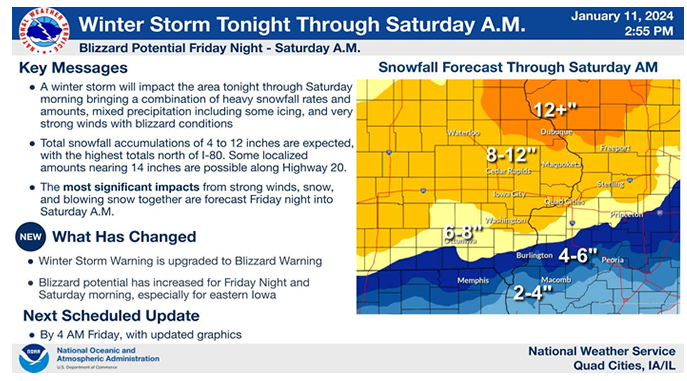
Another winter storm is making its way into eastern Iowa.
The National Weather Service has issued a Winter Storm Warning, with impacts expected late Thursday night through Saturday morning.
Snowfall totals have been upgraded to at least 8 to 12″ across the KMCH listening area for Friday’s winter storm, with Delaware County and points north & east in that 12″ or more range. A glaze of ice is also likely.
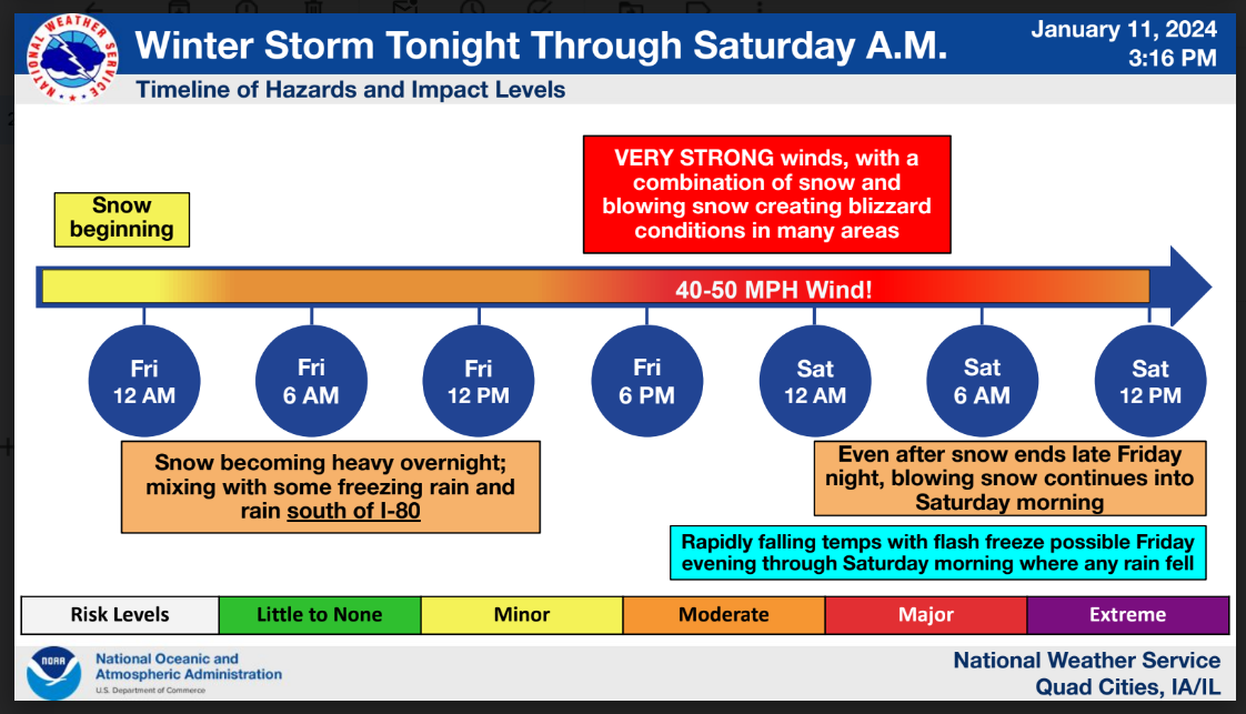
Blizzard conditions are likely Friday night into early Saturday, with winds gusting up to 50 mph and blowing snow/whiteouts. A Blizzard Warning has been issued for Buchanan, Linn and Jones counties starting at 5 pm Friday.
Travel will be VERY dangerous. Please take this storm seriously – make alternate plans and stay off the roads unless absolutely necessary.Â
The coldest air of the season so far will follow this storm system – with highs struggling to reach above zero on Sunday and Monday.
Stay tuned to Mix 94.7 KMCH for the latest weather updates and live & local winter storm coverage. Weather announcements are starting to come in for the weekend – you can find the list on kmch.com.
PREVIOUS STORY (posted Wednesday 4:41 pm)
Just as we’re recovering from our first major winter storm of the season, a second storm isn’t far behind.
A Winter Storm Watch has been issued for eastern Iowa from Thursday evening through Saturday morning.
The National Weather Service says this system will be similar to Tuesday’s storm, with heavy snow possible. Total snow accumulations of four to eight inches is possible, along with a glaze of ice accumulation. Winds could gust as high as 45 mph later Friday and Friday night, producing significant drifting and blowing snow. Rapidly falling temperatures may also produce a flash freeze by Friday evening and add to the slick conditions.
The system is expected to impact portions of north central, northwest and west central Illinois and east central, northeast and southeast Iowa.
Travel could be very difficult and dangerous. Areas of blowing snow could significantly reduce visibility. The hazardous conditions could impact the Friday morning and evening commute. Gusty winds could bring down tree branches.
Stay with KMCH for the latest weather updates.
Stay Connected with 94.7 KMCH
Add 94.7 KMCH as a preferred source on Google to see more local news, weather, and sports in your feed.
Follow us on Facebook for breaking news, severe weather alerts, sports, and more.
