




Severe weather is possible again as we head into Tuesday.
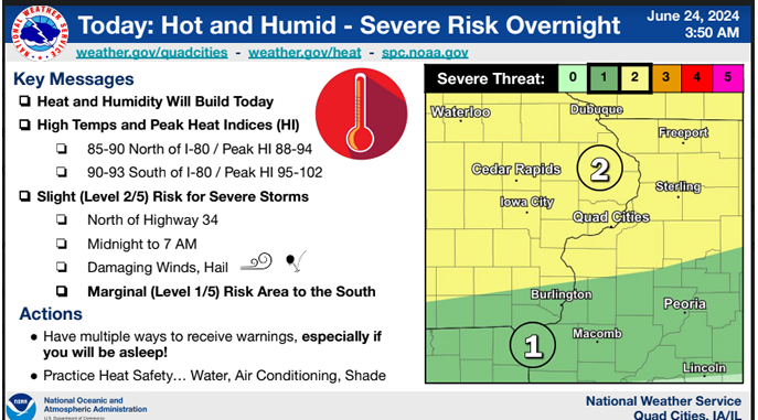
The National Weather Service says heat and humidity is increasing once again, with highs in the mid-80s to low-90s. Heat indices – what it actually feels like outside – is reaching back into the upper 80s to just over 100 in some areas.
The Storm Prediction Center has placed eastern Iowa under a Slight Risk (Level 2 out of 5) for severe weather Tuesday afternoon into Tuesday night. The main threats would be damaging winds, large hail and tornadoes. Torrential rainfall is also expected, which could lead to a flash flood risk.
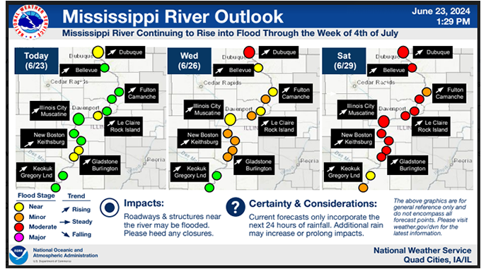
The threat for severe storms comes just a few days after several tornado warnings for the KMCH listening area on Saturday night. Delaware County Emergency Management says several local fire departments reported funnel clouds or rotation, including Strawberry Point, Dundee, Greeley, Edgewood and Earlville. Emergency Management Coordinator Mandy Bieber says they have not received any reports of damage or tornado touchdowns. The storm system moved east/northeast and did go on to produce a EF2 tornado that hit Janesville, Wisconsin. The National Weather Service says Saturday’s severe weather in eastern Iowa was mainly a heavy rain event, dropping two inches or more across parts of eastern Delaware and Dubuque counties. Historic flooding has hit northern Iowa and Delaware County Emergency Management says the Mississippi, Wapsi and Cedar Rivers are expected to see flooding over the next week as well.
As we head through the day on Tuesday, we’ll keep you updated on KMCH by letting you know of any watches and warnings and break in with live coverage as needed.

Stay Connected with 94.7 KMCH
Add 94.7 KMCH as a preferred source on Google to see more local news, weather, and sports in your feed.
Follow us on Facebook for breaking news, severe weather alerts, sports, and more.
