




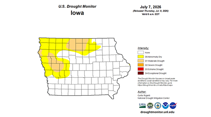
Eastern Iowa has returned to normal conditions, but parts of northwest Iowa are experiencing drought.
The latest Water Summary Update released by the DNR on Thursday says while southeastern Iowa experienced above-average moisture that returned central and eastern portions to normal conditions, the northwest saw an unseasonal dry June. These conditions maintained the active drought watch designation for northwest Iowa under the Iowa Drought Plan, while the rest of the state’s drought regions remain under a normal designation. Concurrently, the U.S. Drought Monitor indicated that approximately one-third of the state is experiencing moderate drought conditions.
Statewide precipitation for June averaged 5.22 inches – that’s pretty close to normal. However, it doesn’t take into account the localized monthly totals that varied from a deficit-heavy 0.92 inches in Cherokee to an isolated high of 14.75 inches in Russell. Temperatures across Iowa averaged 70 degrees, with extreme highs reaching 97 degrees in late June. Overall, June 2026 ties multiple years as the 64th warmest and ranks as the 96th driest June in 154 years of statewide records.
Looking ahead, the National Weather Service’s Climate Prediction Center outlook for July offers no clear signal for temperatures and precipitation statewide. The seasonal outlook suggests that while newly developed dryness in northern Iowa may be removed, drought conditions in the far northwestern region are projected to persist through September.
image courtesy of DNR
Stay Connected with 94.7 KMCH
Add 94.7 KMCH as a preferred source on Google to see more local news, weather, and sports in your feed.
Follow us on Facebook for breaking news, severe weather alerts, sports, and more.
